About FORAGE
The simple way to get a report quickly. All you need is your Lot/Plan. MyFORAGE
Interactive mapping tool to customise your property to create a more targeted report.
- FORAGE is an online system that generates and distributes, in customised PDF reports, information for rural Lots on Plan greater than 1 hectare in area.
- FORAGE incorporates a number of products such as SILO climate data, satellite imagery and modelled pasture growth, delivering them by email as easy to understand PDF property-scale reports, to help decision-making in grazing land and environmental management.
- Benefit-cost analyses (BCAs) of research, development and extension (RD&E) investments were commissioned by the Department of Agriculture and Fisheries, Queensland (DAF) in Phase 2 of the Drought and Climate Adaptation Program (DCAP; 2020). The DES1 project (The inside edge for graziers to master QLD’s drought prone climate: information systems to manage drought more effectively) - which contained a strong FORAGE component revealed a BCA of 5.73.
- FORAGE reports can be requested by Lot on Plan. The option of multiple adjoining Lots on Plan is also possible.
- GeoPDF files are included for selected report maps (i.e. Indicative Land Type, Ground Cover, Foliage Projective Cover, Pasture Growth Alert, Fire Scar, Erodible Soils, Indicative Soil Phosphorous reports) – which can be uploaded to the Avenza maps app on devices such as tablets and mobile phones for onsite property applications.
- A 2-page FORAGE Quick User Guide ( PDF) is available, or for more detail, see the full FORAGE User Guide ( PDF) .
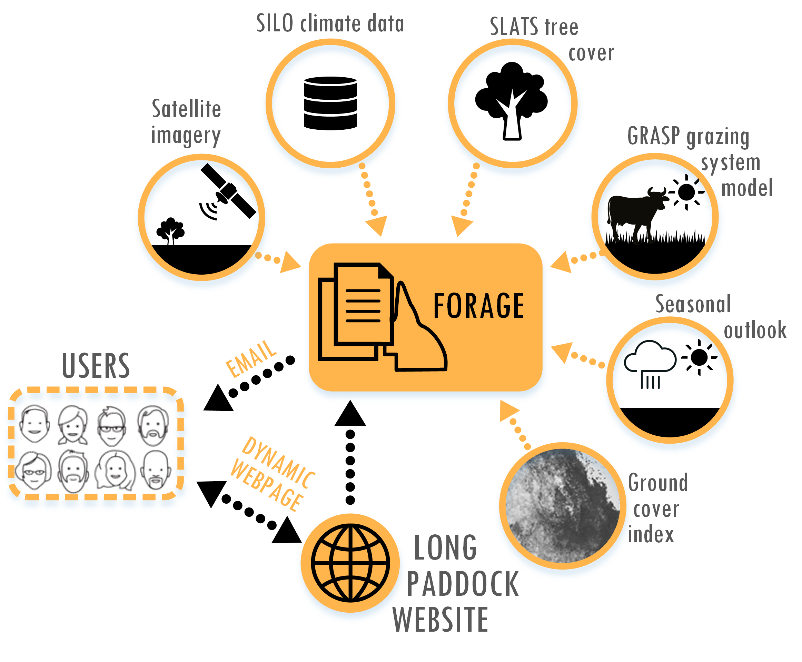
FORAGE flow diagram
Available reports
- Indicative Soil Phosphorus report
- Long-Term Carrying Capacity report
- Pasture Growth Alert
- Rainfall and Pasture by Land Type report
- Ground Cover report
- Regional Comparison Ground Cover report
- Indicative Land Type report
- Foliage Projective Cover report
- Fire Scar report
- Rainfall and Pasture Growth Outlook report
- Regional Climate Projections report
- Drought Assessment report
- Erodible Soils report
- Crop Frequency report
- Landsat satellite imagery (e.g. Ground Cover, Foliage Projective Cover)
How to obtain FORAGE reports and products
- Click “Request report” on the top left hand side menu bar of the FORAGE home page, select the reports you wish to request by clicking the report names. You can now select multiple reports at the same time.
- Provide the Lot(s) on Plan by typing in the Lot(s) on Plan in the space under “Enter lot(s) on plan” (e.g. 3MZ594 for Lot 2, Plan MZ594) and select from list. Select ‘add’ and continue to select if required; or
- Use geolocation tool, the address bar to add the property name, road address, town or just zoom in on the map to find your Lot(s) on Plan and click to select (one or more).
- Select information such as start year and end year if required (report specific), enter your email address and then click on the ‘submit’ button to submit the request.
- A PDF report (or link to product requested) will be emailed to the email address provided.
- Completing requests can range from 10 minutes to a few hours, depending on the complexity of the report and number of requests processing on the system.
User guide
A 2 page FORAGE Quick User Guide ( PDF) is available.
Further information on FORAGE can be found in the FORAGE User Guide ( PDF) .
Other information
Further information on the Remote Sensing Centre and remote sensing products.
While all care has been taken to ensure accuracy, no warranty is given in relation to the data (including accuracy, reliability, completeness or fitness for a particular purpose). In all cases, product accuracy remains limited by the spatial resolution of the input data.
Please see our disclaimer before using the products on these pages.
Reference citation
Zhang B., Carter J. (2018) FORAGE – An online system for generating and delivering property-scale decision support information for grazing land and environmental management. Computers and Electronics in Agriculture, Volume 150, 302-311
