Monthly Climate Statement for October 2011
The Queensland Climate Change Centre of Excellence (the Centre) considers that the probability of above-median rainfall for the remainder of spring and the coming summer (from October 2011 to March 2012) is higher than normal for most of Queensland, although not as high as at the same time last year. The Centre’s view, which is based on a comparison of historical rainfall records and climate indices, is also supported by a range of evidence provided by national and international climate agencies. Read more (PDF, 173K, last updated 08:59AM, 21 October 2011)*
As at 1 October 2011, the Centre notes that sea-surface temperature anomalies in the central equatorial Pacific and other indicators of the El Niño-Southern Oscillation (ENSO) phenomenon have either reached, or exceeded, La Niña thresholds. The Southern Oscillation Index (SOI), an atmospheric measure of ENSO, has averaged +7.6 over the last three months (July to September) and remains at quite positive values (+11.1 in September). Likewise sea-surface temperatures in the equatorial Pacific are at La Niña thresholds. The Bureau of Meteorology, in their latest 'ENSO Wrap-Up' (PDF)* (issued October 12), note: ’Conditions in the tropical Pacific Ocean are consistent with the early stages of a late-forming La Niña event. If the current cooling persists, as is expected, then 2011–12 will be recorded as the second La Niña in as many years. Current observations and model predictions indicate that this La Niña is likely to be weaker than the strong 2010–11 event.’
The Centre has closely monitored sea-surface temperatures in specific regions of the Pacific Ocean since April this year to provide long-lead rainfall probabilities for the coming summer (November to March). These long-lead outlooks are based on the Centre’s experimental Seasonal Pacific Ocean Temperature Analysis (SPOTA-1) scheme. SPOTA-1 takes into account both ENSO and a more persistent, but related, coupled ocean-atmosphere phenomenon known as the Pacific Decadal Oscillation (PDO). Like last year, the SPOTA-1 scheme has consistently indicated that the probability of above-median rainfall for the coming summer is higher than normal. The Centre has also encouraged readers of this monthly climate statement to continue to monitor the monthly updates, as rainfall probabilities based on this scheme can change. The Centre will make a final assessment of rainfall probabilities for summer (November to March) next month when the SPOTA-1 indices are most accurate. Next month the Centre will also calculate rainfall probabilities for November to January, December to February and January to March. These probabilities won’t be revised as the sea-surface temperature signal for each of these periods is strongest during October. However the Centre will continue to monitor the SOI and sea-surface temperatures and provide commentary on this basis.
There are various approaches used to provide rainfall outlooks based on the information available. These approaches tend to differ in terms of the components of the climate system that are considered and, for this reason, each approach may convey a different outlook, particularly for specific locations.
The Centre produces two statistical climate risk assessment schemes. They are:
- the experimental SPOTA-1 scheme, which integrates sea-surface temperature information, including indices of ENSO and the PDO, and
- the SOI phase scheme, which relies solely on the SOI, an atmospheric measure of ENSO.
The Centre's experimental SPOTA-1 scheme provides long-lead probabilities of summer (November to March) rainfall for Queensland from mid-April through to mid-November each year. The sea-surface temperature gradient (west to east) across the South Pacific Convergence Zone (i.e. between eastern Australia and the central Pacific) remains positive (+1.15 ºC). According to the Centre's experimental SPOTA-1 scheme, a positive sea-surface temperature gradient across this region is favourable for summer rainfall in Queensland. The SPOTA-1 scheme currently indicates a higher than normal probability of above-median rainfall throughout Queensland over the coming summer.
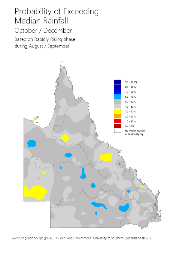
The Centre's SOI phase scheme provides probabilities of rainfall for the coming three-month season based on SOI values over the previous two months. The SOI phase scheme currently indicates that the probability of exceeding median rainfall across most of Queensland is slightly higher than normal (50 per cent) for the next three-month period (October to December). This analysis is based on the fact that the SOI has risen strongly from August to September as discussed further in the Centre's Australia's Variable Rainfall poster (PDF, 1.0M, last updated 11:42AM, 24 June 2010)* or the Centre's archive of historical rainfall maps).
The Centre understands that each of the schemes may have its own particular following. Although such schemes cannot provide outlooks with absolute certainty, users of the information who follow a skilful scheme should benefit from doing so in the long-term. Users should consider the historical track record of any scheme and such information is becoming increasingly available. The Centre's Long Paddock website provides the historical archive of SPOTA-1 reports and past commentaries on the SOI phase scheme. Users should also consider the wide range of information available each month describing the current state of the ocean/climate system, for example the 'ENSO Wrap-Up' (PDF)*.
For further information, please visit www.LongPaddock.qld.gov.au or contact QCCCE@climatechange.qld.gov.au
* Requires Adobe Reader
