Monthly Climate Statement for September 2012
It is considered that the probability of above-median rainfall for the next three-month period (September to November) is near-normal (40 to 60 per cent) for most of Queensland. For the coming summer (November to March), the long-range experimental Seasonal Pacific Ocean Temperature Analysis version one (SPOTA-1) scheme currently indicates a slightly higher than normal (50 to 70 per cent) probability of above-median rainfall for most of Queensland. Read more (PDF, 251K, last updated 11:50AM, 20 September 2012)*
This assessment is based on the current and projected state of the El Niño-Southern Oscillation (ENSO) phenomenon and on factors which alter the impact of ENSO on Queensland rainfall (e.g. the Pacific Decadal Oscillation (PDO)). The outlook for the September to November period is based on an historical analysis of Queensland rainfall and the SOI. The long-lead outlook for summer is based on the current sea-surface temperature pattern in the extra-tropical Pacific.
As at 1 September 2012, it is noted that sea-surface temperature anomalies in the central equatorial Pacific are near El Niño thresholds. However, some atmospheric indicators of ENSO (i.e. trade winds and cloudiness near the Date Line) have yet to show patterns that are typical of an El Niño.
Approximately 70 per cent of international global climate models indicate the possibility of an El Niño event developing before summer. Models surveyed by the Bureau of Meteorology (‘ENSO Wrap-Up’ (PDF)* September 11) suggest that sea-surface temperatures in the tropical Pacific Ocean will maintain values close El Niño thresholds, before returning to more neutral values toward the end of 2012 or early 2013.
In addition:
- The SOI, a key atmospheric measure of ENSO, fell from a near-zero value in July (+0.1) to a below average value (-6.2) in August.
- Observed sea-surface temperatures in the key Niño 3.4 region were 0.7º C above normal during August.
- Further warming of central Pacific sea-surface temperatures, coupled with atmospheric features typical of an El Niño, including negative SOI values over the coming months, would be required to confirm the development of an El Niño pattern.
Rainfall outlook
There are various approaches used to provide rainfall outlooks. These approaches tend to differ in terms of the components of the climate system that are considered and, for this reason, each approach may convey a different outlook, particularly for specific locations.
DSITIA produces two statistical climate risk assessment schemes. They are:
- the experimental SPOTA-1 scheme, which integrates sea-surface temperature information, including indices of ENSO and the PDO; and
- the SOI Phase scheme, which relies solely on the SOI, an atmospheric measure of ENSO.
The experimental SPOTA-1 scheme provides long-lead probabilities of summer (November to March) rainfall for Queensland from mid-April through to mid-November each year.
An updated assessment of rainfall probabilities for the upcoming 2012/13 summer, based on the experimental SPOTA-1 scheme, indicates a slightly higher than normal probability of above-median rainfall for much of Queensland. This assessment is based, in part, on an index of March sea-surface temperature anomalies which reflect the current ‘cool’ state of the PDO. This latest assessment, which also takes into account a monthly ENSO index, will be revised from October through to November this year.
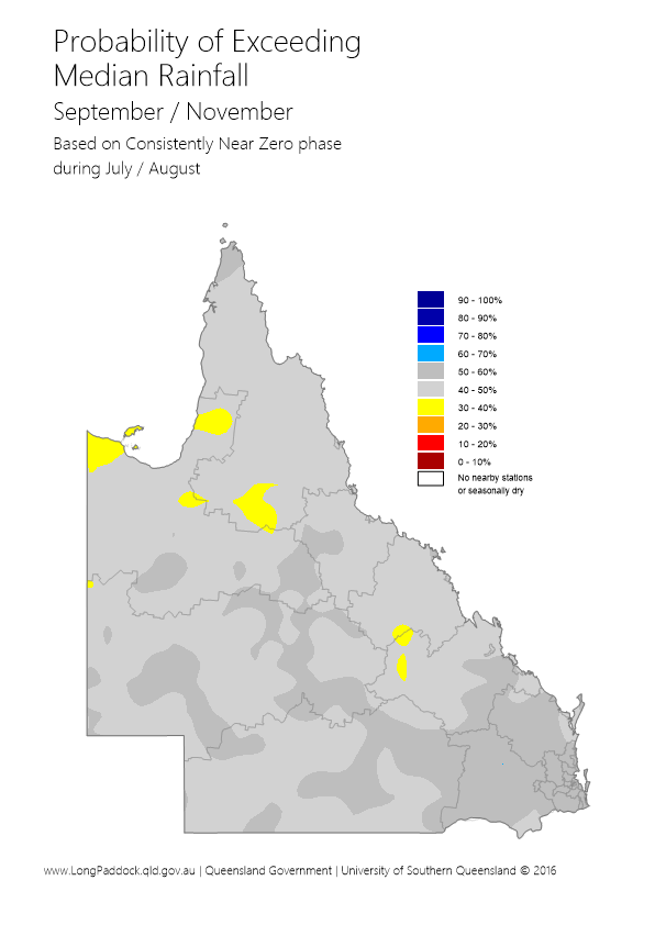
DSITIA’s SOI Phase scheme provides probabilities of rainfall for the coming three-month season based on SOI values over the previous two months. The SOI Phase scheme currently indicates that the probability of above-median rainfall across most of Queensland is 40 to 60 per cent for the next three-month period (September to November). This analysis is based on the SOI being in a ‘Consistently Near-Zero’ phase at the end of August, as discussed further in the Australia's Variable Rainfall poster (PDF, 9.3M, last updated 03:09PM, 29 July 2016)*, or the Department's archive of historical rainfall maps).
Each of the above schemes may have their own particular following. Although such schemes cannot provide outlooks with absolute certainty, users of the information who follow a skilful scheme should benefit from doing so in the long-term. Users should consider the historical track record of any scheme, and such historical information is becoming increasingly available.
DSITIA's Long Paddock website provides the historical archive of SPOTA-1 reports and past commentaries on the SOI phase scheme. Users should also consider the wide range of information available each month describing the current state of the ocean/climate system, for example the 'ENSO Wrap-Up' (PDF)*.
ENSO influences other climate variables apart from rainfall (e.g. temperature, pan evaporation and vapour pressure). This means that the impact of ENSO on crop or pasture growth can be stronger than on rainfall alone. The impact of ENSO on pasture growth is also dependent upon current pasture condition and soil water status. DSITIA’s AussieGRASS model takes these factors into account in producing seasonal pasture growth probabilities.
* Requires Adobe Reader
