Monthly Climate Statement for April 2015
The Science Division of the Department of Science, Information Technology and Innovation (DSITI) considers that, for most of Queensland, there is a lower than normal probability of exceeding median rainfall over the next three-month period (April to June). This view is based on an analysis of the historical relationship between Queensland rainfall and the Southern Oscillation Index (SOI) which, at this time of year, is quite weak. The probability of exceeding median summer (November to March 2015/16) rainfall is currently slightly higher than normal for most of Queensland, based on DSITI’s analysis of the March extra-tropical Pacific Ocean sea surface temperature (SST) pattern. Read more (PDF, 357K, last updated 11:57AM, 15 April 2015)*
DSITI’s rainfall outlooks for Queensland are based on the current and projected state of the El Niño–Southern Oscillation (ENSO) phenomenon and on factors which alter the impact of ENSO on Queensland rainfall (i.e. the more slowly changing extra-tropical SST pattern in the Pacific Ocean).
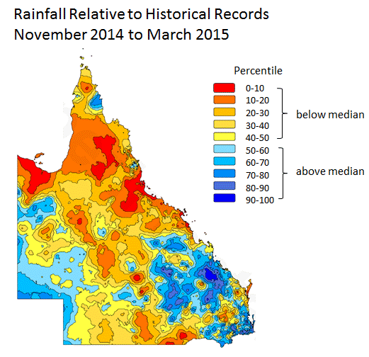
Rainfall for the summer period (November to March) was below median for much of Queensland, although parts of the state recorded well-above median summer rainfall.
Currently, more than 75 per cent of Queensland remains drought declared under state government processes, including most inland regions and all of south-eastern Queensland.
The El Niño - Southern Oscillation (ENSO)
At this time of year (known as the ‘autumn predictability gap’), the ENSO pattern tends to change very rapidly. Although the change in the ENSO pattern over autumn may provide a guide as to the likely development of El Niño or La Niña events, it is not until late autumn (May) that the prevailing ENSO pattern (as measured by indices such as the SOI or central equatorial Pacific Ocean SST anomalies) begins to provide a useful basis for seasonal forecasting (i.e. for providing rainfall outlooks for winter, spring or summer). However, it is useful to monitor the change in ENSO indices over this time of year as a guide as to whether an El Niño or La Niña pattern may develop. Global climate models also provide a more formal means of assessing this likelihood.
Currently:
- The monthly value of the SOI fell sharply from -0.5 in February to -10.7 in March and, as at 13 April, the 30-day mean value was -8.4.
- The monthly SST anomaly in the Niño 3.4 region of the central equatorial Pacific Ocean rose slightly from +0.56 ºC in February to +0.58 ºC in March. As at 11 April the latest weekly SST anomaly was +0.7 ºC.
- Although definitions of ‘El Niño’ vary, DSITI’s ‘Australia’s Variable Rainfall (PDF, 9.3M, last updated 03:09PM, 29 July 2016)*’ poster stipulates that an El Niño event occurs if any six-month period, ending between November and March, has an average SOI value less than -6.0. This criterion for an El Niño has been met each month since November last year, based on the Bureau of Meteorology’s calculation of the SOI (six-month average SOI values being -6.9, -7.6, -8.4, -6.4 and -6.9 in November, December, January, February and March respectively). Also, since November, warm SST anomalies in the central equatorial Pacific have met the World Meteorological Organisation’s operational ‘consensus’ definition of El Niño (three-month anomaly at or above +0.5 ºC) as well as NOAA’s definition based on their Oceanic Niño Index (five consecutive overlapping three-month periods at or above +0.5 ºC).
- Most international global climate models currently indicate that central equatorial Pacific Ocean SSTs should continue to warm in the coming months, with a higher than normal probability of El Niño conditions over winter and possibly spring. At this stage, DSITI considers that it is too early to factor an El Niño into risk management.
Seasonal rainfall outlook (Apr-Jun 2015)
An analysis of rainfall probabilities as at 1 April based on the SOI being in a ‘Rapidly Falling’ phase indicates, for most of Queensland, a lower than normal probability of exceeding median rainfall over the next three-month period (April to June).
Summer rainfall outlook (Nov-Mar 2015/16)
DSITI scientists have shown that extra-tropical SST anomalies, when measured in specific regions of the Pacific Ocean in March each year, provide a useful basis for long-lead forecasting of summer (November to March) rainfall in Queensland. The accuracy of this outlook increases as the evolving ENSO-related SST pattern is also taken into account from May through to October.
This understanding has been incorporated in an experimental system known as SPOTA-1 (Seasonal Pacific Ocean Temperature Analysis version 1), which has been operationally evaluated by DSITI scientists for over a decade.
As at 1 April 2015, DSITI’s initial long-lead outlook for the coming summer (November to March 2015/16) indicates a slightly higher than normal probability of exceeding median rainfall for most of Queensland. This outlook indicates that the current warmer than normal extra-tropical SSTs east of Australia may have a favourable influence on Queensland summer rainfall.
Updates to the summer rainfall outlook will be reported in future Monthly Climate Statements.
* Requires Adobe Reader
